The Role of Satellite Technology in Deforestation Monitoring

Deforestation is a primary global concern,
impacting biodiversity, climate stability, and carbon sequestration. As forests
disappear alarmingly, tracking and preventing illegal deforestation has become
more critical. However, traditional monitoring methods, such as ground surveys
and aerial mapping, are often costly, time-consuming, and limited scope.
This is where satellite technology plays
a transformative role. Advanced remote sensing and AI-driven analytics
allow real-time deforestation monitoring, enabling rapid response and accurate
assessments. Companies like SpaceKnow are at the forefront of this
innovation, using cutting-edge satellite technology to provide real-time
environmental monitoring and deforestation tracking solutions on a
global scale.
Why Deforestation Monitoring is
Crucial
Forests are essential in maintaining ecological
balance, absorbing carbon dioxide, and sustaining biodiversity. However,
illegal logging, land conversion for agriculture, and urbanization continue to
drive deforestation at an alarming pace.
Challenges of traditional monitoring
methods include:
- Limited ground access in remote regions.
- High costs of aerial surveys and manual
data collection.
- Inconsistent reporting due to reliance on
local sources.
To overcome these challenges, space-based
monitoring provides a reliable, scalable, and cost-effective solution for
tracking forest loss and taking action before irreversible damage occurs.
The Evolution of Satellite
Technology in Deforestation Monitoring
Satellite monitoring has been around for
decades, but recent satellite imagery and AI-powered analytics
advancements have revolutionized deforestation tracking.
Key advancements include:
- High-resolution imagery: Modern satellites capture highly detailed
images, allowing for precise deforestation mapping.
- Synthetic Aperture Radar (SAR): Unlike optical sensors, SAR can penetrate
cloud cover and detect changes in dense forest areas.
- AI-driven analysis: Machine learning models can automate
deforestation detection, flagging areas of concern faster than human
analysts.
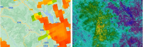
How SpaceKnow's Satellite Technology
Tracks Deforestation
SpaceKnow leverages satellite data, AI, and
advanced analytics for accurate, independent, high-frequency
deforestation monitoring.
SpaceKnow's unique approach:
- Global Pollutant Evaluation: Tracks environmental degradation across
over 600 regions worldwide.
- AI-Powered Change Detection: Uses advanced algorithms to detect
changes in forest cover automatically.
- Deforestation and Reforestation Tracking: Assesses forest loss and regrowth areas
to support sustainability efforts.
This real-time intelligence allows
organizations, governments, and ESG investors to act swiftly in
preventing environmental damage.
Real-Time Data Collection and
AI-Driven Analytics
Real-time data availability is one of the most
significant advantages of Deforestation monitoring space. Traditional
methods often result in delays, but satellite technology enables instant
access to forest change data, making it easier to enforce environmental
laws.
How AI enhances deforestation
tracking:
- Automated alerts: Detects forest loss as soon as it
happens.
- Predictive analysis: AI models help forecast future
deforestation risks.
- Integration with ESG reporting: Provides data-backed sustainability
metrics for businesses and investors.
This combination of AI and remote sensing
allows for a proactive approach to conservation rather than reactive
damage control.
Case Studies: Successful
Deforestation Prevention with Space-Based Monitoring
1. Tracking
Illegal Logging in the Amazon Rainforest
Using SpaceKnow's high-resolution satellite imagery,
environmental agencies identified unauthorized logging activities in
Brazil's Amazon region. By pinpointing illegal deforestation zones, they took
action against violators, reducing further damage.
2. Supporting
ESG Compliance for Corporations
Large corporations aiming to meet Environmental,
Social, and Governance (ESG) goals use SpaceKnow's monitoring solutions to
track their supply chain's impact on forests. This helps them align with
sustainability commitments and maintain transparency.
3. Conservation
Efforts in Southeast Asia
Southeast Asian governments partnered with SpaceKnow's
satellite monitoring system to track deforestation rates caused by palm
oil plantations, allowing them to implement stricter land-use policies.
The Future of Space-Based
Deforestation Monitoring
Satellite technology is rapidly evolving, and
its role in environmental conservation will grow stronger.
Upcoming trends include:
- Increased AI automation for faster and more accurate
deforestation detection.
- More excellent satellite coverage with higher-resolution imagery.
- Improved integration with ESG reporting
tools, helping businesses meet sustainability
goals more efficiently.
SpaceKnow continues to push the boundaries of space-based
environmental monitoring, helping organizations take meaningful action
toward forest conservation.
Conclusion
Deforestation monitoring has come a long way,
and satellite technology has proven to be a game-changer in environmental
protection. With real-time data collection, AI-driven analytics, and
independent verification, companies like SpaceKnow empower
businesses, governments, and conservationists to track, analyze, and prevent
deforestation more effectively than ever.
🚀 Want
to learn how SpaceKnow can help with deforestation monitoring? Visit SpaceKnow's
ESG Solutions today.

Comments
Post a Comment